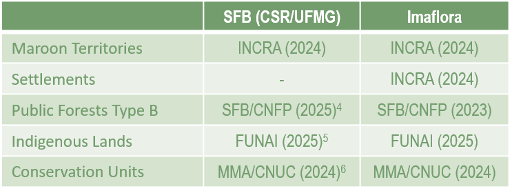
Our study considered two rural property databases for executing the Forest Code (FC) model: the Brazilian Forest Service database (downloaded in January 2024)1 and the processed database from the Institute of Forest and Agricultural Management and Certification (IMAFLORA)2. Only Rural Properties (IRU) were included from both datasets, excluding settlements (AST) and quilombola (maroon) territories (PCT). After cartographic processing of the databases, registrations overlapping conservation units (except Environmental Protection Areas – APAs and Private Natural Heritage Reserves – RPPNs), Indigenous lands, and type B public forests (here referred to as undesignated public lands – TPSD) were excluded, adhering to the Federal Prosecutor’s Office protocol thresholds3. Additionally, registrations with canceled status were not included in either dataset. The IMAFLORA processed dataset, beyond removing IRU overlaps with INCRA settlements and quilombola (maroon) territories, also included a cleaning process to resolve overlaps among different IRU types through metric calculations and hierarchy definitions to mitigate spatial inconsistencies in the self-declared SICAR records. The data sources for protected areas are listed in the table below.
The model also uses input maps such as state and municipal boundaries, municipal fiscal modules, the Legal Amazon boundary, vegetation distribution, hydrography, land use, deforestation, and protected areas5-16. We used the IBGE (Brazilian Institute of Geography and Statistics) municipality map to assign the municipal geocode to each CAR record.
Since each Brazilian municipality has a specific fiscal module size, the geocode allows the fiscal module size to be assigned to the CAR. The FC classifies properties as small if they are 1 to 4 fiscal modules10, medium if they are between 4 and 15 fiscal modules, and large if they are larger than 15 fiscal modules.
Public conservation units (except APAs) and homologated and regularized Indigenous lands were used to calculate the area covered by protected areas per municipality and state, and the resulting numbers were assigned to the CAR code via geocode.
The Legal Amazon boundary has been extended several times due to changes in the country’s political divisions. For our model exercise, we used the IBGE-defined Legal Amazon boundary11 to determine the percentage of Legal Reserve (LR) for restoration purposes.
The PRODES vegetation formations were used to determine the LR percentage in the Legal Amazon: 80% for forest formations and 35% for other vegetation types. Outside the Legal Amazon, the FC establishes 20% of the rural property as LR. When a property overlaps more than one vegetation type, a weighted average is applied. Specifically, in the state of Piauí, a 30% LR was applied within the Cerrado biome domain, as defined by State Law No. 5,699 of November 26, 200717. The LR restoration percentage map included a 50% class representing regions eligible for LR reduction for regularization purposes under Article 13 of the FC. To identify these areas, databases on biodiversity conservation priority areas18 and state ecological-economic zoning (ZEE) approved by the federal government were used.
To calculate APP conservation and restoration requirements, we used hydrography maps, including drainage networks, springs, and water bodies, from the National Water and Basic Sanitation Agency (ANA)7,8. The land use map is a mosaic composed of water bodies, remaining native vegetation, and agricultural areas (“consolidated areas”) from MapBiomas (2008 dataset, collection 8.0)12 and deforestation maps from PRODES-Brazil, PRODES-Legal Amazon, and PRODES-Cerrado13-15. Complementary datasets from the PRODES-Amazon biome31 were also considered, including suppression polygons smaller than 6.25 hectares and those occurring in non-forest areas. Additionally, the class of deforested areas after 2008 was filtered to remove areas smaller than 6.25 hectares before incorporating them into the land use mosaic.
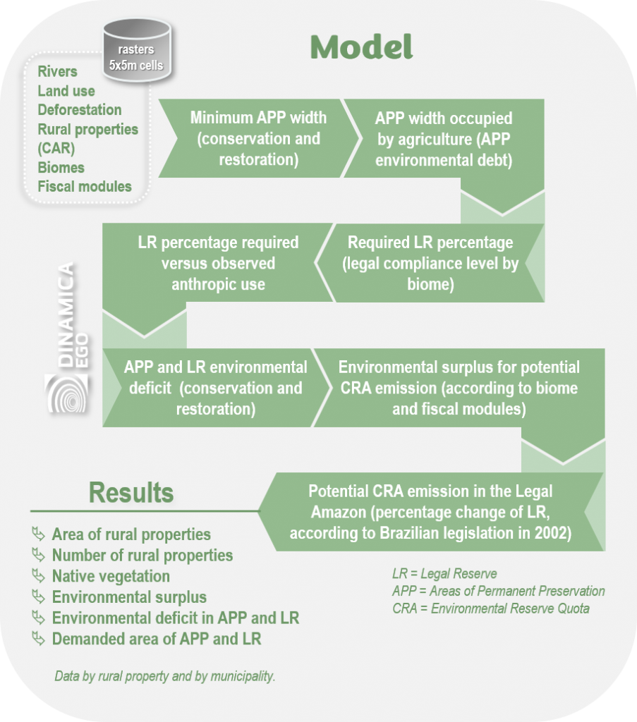
Based on the CAR perimeter, we applied the rules and definitions of the Forest Code (FC)19 for each IRU in the CAR database (SFB and Imaflora). By doing so, we provided estimates of compliance levels with the FC, i.e., deficits—areas that must be reforested at the owners’ expense—or surpluses, native vegetation areas exceeding FC conservation requirements (Fig. 1).
To achieve this, we developed a set of geoprocessing tools capable of handling large datasets (Big Geodata) using PostgreSQL and PostGIS extensions, and the open-source software Dinamica EGO 7*20. Dinamica EGO employs intrusive parallel processing21. Its execution system uses a variable number of execution threads (called workers) driven by task-stealing algorithms to balance the load and increase flexibility for running tasks in parallel. In theory, all model components can run in parallel, including operators, loops and independent map tiles22,23.
Substantial improvements in our computational capacity, including the development of modeling tools, have enabled a fine-scale reanalysis of the FC24,25, making it feasible to estimate FC balances (compliance levels) across Brazil’s territory at the rural property scale. These advances allowed us to move from a spatial resolution of 60 meters24 to 5 meters (the minimum width of APP for restoration). All model components ran using computational resources from the Remote Sensing Center of the Federal University of Minas Gerais26. The model (csr.ufmg.br/radiografia_do_car) can be inspected and replicated via Dinamica EGO’s graphical interface, ensuring an open, transparent, and accessible methodology.
To calculate the forest balance (deficit and surplus), the model first calculates the total area of each IRU where the law applies. The model then generates minimum-width buffers for APP required for both conservation and restoration along rivers, around springs and water bodies (Fig. 1). To define buffer sizes, the model uses the IRU size (defined by the number of fiscal modules specified for each municipality) and river width. For riparian APP restoration buffers, the model applies a series of rules known as the “escadinha”, based on property size (defined by number or fiscal module as specified for each municipality) and river width.
Next, the model applies FC rules according to property size to define LR requirements. In the Amazon biome, we considered increasing the LR size from 50% to 80%, as established by Provisional Measure 1,511 of 1996 and 2,166-67 of 2001 for conservation purposes. However, article 68 of the FC establishes that landowners who cleared native vegetation in compliance with previous legislation are not required to restore LR to the current legal percentage (i.e., 80%). This resolved conflicting prior legislation to legalize “properties pushed into illegal status.” Additionally, the FC allows LR restoration percentages to be reduced by up to 50% in municipalities where over 50% of the territory is occupied by conservation units or Indigenous reserves (Art. 12, II – §4) and specifies a maximum percentage of the property for APP restoration (Art. 61-B), depending on the total riparian APP (Art. 15). The FC also establishes that LR restoration percentages can be reduced to 50% in consolidated zones within Legal Amazon states with approved Ecological-Economic Zoning (ZEE). Finally, the law exempts smallholders (up to 4 fiscal modules) from restoring LR deficits (Art. 67).
The difference in LR definition by Article 68 of the FC is why we separate deforestation before and after 2002. Deforestation before and after this date must be analyzed under different LR size specifications. Furthermore, the deforestation occurrence date is also evidence for applying article 68 of the 2012 FC, as specified in paragraph 1:
“Owners or possessors of rural properties may prove these consolidated situations through documents such as historical descriptions of regional occupation, marketing records, agricultural data, contracts, and banking documents related to production, and by all other means of evidence admitted by law”19.
The primary sequence to obtain the FC balance is shown in figure 1. For each IRU, the model subtracts the total LR area required from the remaining native vegetation within each private property and from native vegetation within APP buffers to determine compliance levels. Positive results indicate environmental surplus, while negative results indicate environmental deficits. Legal reserves declared outside rural properties were not evaluated. Uncertainties in FC estimates arise from property overlaps, differing drainage databases, and the accuracy and cartographic scale of land-use mappings.
For traceability and verification of the environmental compliance of agricultural commodity suppliers, the results of the FC balance for rural properties are integrated with deforestation maps13-16, land-use maps from the Mappia project and crops (MapBiomas, collection 8)12,27-29, environmental enforcement records (e.g., embargoes), authorizations for native vegetation suppression, and other relevant federal and state data to ensure transparency in supply chains. These analyses enable the identification of deforestation, further distinguishing between legal and illegal deforestation (without native vegetation suppression authorization). Currently, three states — Pará, Minas Gerais, and Maranhão — use the technologies provided by the platform, and other versions are under development for additional states.
Analyses using SeloVerde indicate, for example, that agricultural products from Minas Gerais show a high level of compliance with the Forest Code. Transparently, SeloVerde demonstrates that the five currently monitored commodities can be considered deforestation-free or low-risk according to international regulations (e.g., European Union and United Kingdom).
Through the SeloVerde platform, any user can access and download an official report with indicators of the socio-environmental compliance level of a rural property and its production, as well as a property map that, in the online version, is interactive. To do so, users simply enter the CAR code of the record on the SeloVerde PA or SeloVerde MG platform website.
Being public and free, the platform can be easily used for due diligence in available commodity supply chains: cattle and soy in Pará; coffee, forestry, sugarcane, soy, and cattle in Minas Gerais.
The CAR 2.0 system, in turn, uses spatially explicit models based on high-resolution land-use mapping to support CAR analysis and validation. It is a tool designed to automatically analyze all rural properties registered in a territory and monitor compliance with legislation, identifying potential impediments or environmental liabilities to be addressed by landowners or occupants.
Producers whose automatic analyses are completed (with no environmental impediments or with LR surpluses) can also use the results to apply for reduced interest rates in rural credit, in accordance with the Plano Safra. This territorial intelligence solution has already been implemented in two states, Pará and Minas Gerais, and is under development for other states in Brazil.
The automatic analysis allows authorities to prioritize CAR records with potential socio-environmental irregularities, promptly identifying necessary solutions for registry regularization.
With CAR 2.0, the number of registrations with completed analysis in Minas Gerais increased from 0.02% to 36.78%. As a result, approximately 387,000 rural properties are now eligible for economic benefits due to their environmental compliance.
- Serviço Florestal Brasileiro – SFB (2024) Sistema Nacional de Cadastro Ambiental Rural. Brasília: SFB. Disponível em: <https://consultapublica.car.gov.br/publico/estados/downloads>.
- Instituto de Manejo e Certificação Florestal e Agrícola – Imaflora (2024) Base de dados processada do CAR do Brasil. São Paulo: Imaflora. Disponibilidade via solicitação.
- Ministério Público Federal – MPF (2020) Protocolo de monitoramento de fornecedores de gado da Amazônia. Brasília: MPF. Disponível em: <https://www.mpf.mp.br/atuacao-tematica/ccr4/dados-da-atuacao/grupos-de-trabalho/amazonia-legal/Protocolodemonitoramentodegadov.12.05.2020.pdf/view>.
- Serviço Florestal Brasileiro (2023) Cadastro Nacional de Florestas Públicas de 2022. Brasília: SFB. Disponível em: <https://www.gov.br/florestal/pt-br/assuntos/cadastro-nacional-de-florestas-publicas/cadastro-nacional-de-florestas-publicas-atualizacao-2022/cnfp-2022>.
- Fundação Nacional dos Povos Indígenas – FUNAI (2023) Terras indígenas. Brasília: FUNAI. Disponível em: <https://geoserver.funai.gov.br/geoserver/web/wicket/bookmarkable/org.geoserver.web.demo.MapPreviewPage?1&filter=falsefonte_entidade>.
- Ministério do Meio Ambiente – MMA (2023) Unidades de conservação. Brasília: MMA. Disponível em: <https://dados.mma.gov.br/dataset/44b6dc8a-dc82-4a84-8d95-1b0da7c85dac/resource/9ec98f66-44ad-4397-8583-a1d9cc3a9835/download/shp_cnuc_2023_07-1.zipfonte_entidade>.
- Agência Nacional de Águas – ANA (2017) Base Hidrográfica Ottocodificada 1:250.000 (BHO250). Brasília: ANA. Disponível em: <https://metadados.snirh.gov.br/geonetwork/srv/por/catalog.search#/metadata/0f57c8a0-6a0f-4283-8ce3-114ba904b9fe>.
- Agência Nacional de Águas – ANA (2019) Massas d’água – versão 2019. Brasília: ANA. Disponível em:<https://metadados.snirh.gov.br/geonetwork/srv/por/catalog.search;jsessionid=2D7CA1AA9B2C516E7BA71AE6BF8A65B0#/metadata/7d054e5a-8cc9-403c-9f1a-085fd933610c>.
- Instituto Brasileiro de Geografia e Estatística – IBGE (2022) Malha Municipal. Rio de Janeiro: IBGE. Disponível em: <https://www.ibge.gov.br/geociencias/organizacao-do-territorio/malhas-territoriais/15774-malhas.html>.
- Instituto Nacional de Colonização e Reforma Agrária – INCRA (2013) Módulos fiscais por município do Brasil. Brasília: INCRA. Disponível em: <https://www.gov.br/incra/pt-br/assuntos/governanca-fundiaria/modulo-fiscal>.
- Instituto Brasileiro de Geografia e Estatística – IBGE (2022) Limites da Amazônia Legal. Rio de Janeiro: IBGE. Disponível em: <https://www.ibge.gov.br/geociencias/organizacao-do-territorio/estrutura-territorial/15819-amazonia-legal.html?edicao=30963&t=acesso-ao-produto>.
- Projeto de Mapeamento Anual da Cobertura e Uso do Solo no Brasil – MapBiomas (2023) Mapas de uso da terra – coleção 8.0. Disponível em: <https://brasil.mapbiomas.org/colecoes-mapbiomas/>.
- Instituto Nacional de Pesquisas Espaciais – INPE (2023) Projeto Prodes – Monitoramento do Desmatamento no Brasil por Satélite. São José dos Campos: INPE. Disponível em: <http://terrabrasilis.dpi.inpe.br/downloads/>.
- Instituto Nacional de Pesquisas Espaciais – INPE (2024) Projeto Prodes – Monitoramento do Desmatamento na Amazônia Legal por Satélite. São José dos Campos: INPE. Disponível em: <http://terrabrasilis.dpi.inpe.br/downloads/>.
- Instituto Nacional de Pesquisas Espaciais – INPE (2024) Projeto Prodes – Monitoramento de Desmatamento no Cerrado. São José dos Campos: INPE. Disponível em: <http://terrabrasilis.dpi.inpe.br/downloads/>.
- Instituto Nacional de Pesquisas Espaciais – INPE (2024) Projeto Prodes – Monitoramento do Desmatamento no bioma Amazônia por Satélite. São José dos Campos: INPE. Disponível em: <http://terrabrasilis.dpi.inpe.br/downloads/>.
- Piauí (2007) Lei Nº 5.699 (26 de novembro de 2007). Disponível em: <https://sapl.al.pi.leg.br/media/sapl/public/normajuridica/2007/480/480_texto_integral.pdf>.
- Ministério do Meio Ambiente – MMA (2019) 2ª Atualização das Áreas Prioritárias para Conservação da Biodiversidade 2018. Brasília: MMA. Disponível em: <https://www.gov.br/mma/pt-br/assuntos/servicosambientais/ecossistemas-1/conservacao-1/areas-prioritarias/2a-atualizacao-das-areas-prioritarias-para-conservacao-da-biodiversidade-2018>.
- Brasil (2012) Lei Federal Nº 12.651 (25 de maio de 2012). Disponível em: <https://www.planalto.gov.br/ccivil_03/_ato2011-2014/2012/lei/L12651.htm>.
- Soares-Filho BS, Rodrigues HO, Follador M (2013) A hybrid analytical-heuristic method for calibrating land-use change models. Environmental Modelling & Software 43, 80-87.
- Leite-Filho AT, Soares-Filho BS, Davis JS, Rodrigues HO (2020). Guidebook 2.0 Dinamica EGO. Disponível em: <https://www.csr.ufmg.br/dinamica/dokuwiki/doku.php?id=guidebook_start>.
- Rana S (1993) A distributed solution of the distributed termination problem. Information Processing Letter 17, 43-46.
- Blumofe R, Leiserson C (1999) Scheduling multithreaded computations by work stealing. Journal of Association for computing Machinery 46, 720-748.
- Soares-Filho BS, Rajão R, Macedo M, Carneiro A, Costa WLS, Coe M, Rodrigues HO, Alencar A (2014) Cracking Brasil’s Forest Code. Science 344, 363-364.
- Soares-Filho BS, Rajão R, Merry F, Rodrigues H, Davis J, Lima L, Macedo M, Coe M, Carneiro A, Santiago L (2016) Brazil’s Market for trading forest certificates. Plos One 11(4): e0152311.
- Centro de Sensoriamento Remoto da Universidade Federal de Minas Gerais (CSR/UFMG). Disponível em: <www.csr.ufmg.br>.
- Empresa de Assistência Técnica e Extensão Rural do Estado de Minas Gerais – EMATER (2020) Mapeamento do parque cafeeiro de Minas Gerais. Disponível em: https://portaldocafedeminas.emater.mg.gov.br/.
- Instituto Estadual de Florestas de Minas Gerais – IEF-MG (2023) Mapeamento de Florestas plantadas do estado de Minas Gerais. Disponibilidade via solicitação.
- Associação das Indústrias Sucroenergéticas de Minas Gerais – SIAMIG (2024) Mapeamento de Cana-de-açúcar do estado de Minas Gerais. Disponibilidade via solicitação.
- Instituto Estadual de Florestas – IEF, Centro de Sensoriamento Remoto da Universidade Federal de Minas Gerais – CSR-UFMG (2024) CAR 2.0: Impulsionando a Análise do Cadastro Ambiental Rural (CAR) com ciência e tecnologia no estado de Minas Gerais. Belo Horizonte: CSR/UFMG. Disponível em: <https://csr.ufmg.br/car20_mg/wp-content/uploads/2024/06/nota_tecnica-car2-0.pdf>.
- Ministério da Agricultura e Pecuária – MAPA (2024) Governo Federal lança Plano Safra 24/25 com R$ 400,59 bilhões para agricultura empresarial. Brasília: MAPA. Disponível em: <https://www.gov.br/agricultura/pt-br/assuntos/noticias/governo-federal-lanca-plano-safra-24-25-com-r-400-59-bilhoes-para-agricultura-empresarial>.